Tag:amenity=ferry_terminal
Jump to navigation
Jump to search
| Description |
|---|
| A place where people, cars etc. can board and leave a ferry. |
| Rendering in OSM Carto |
| Rendering in OSM Carto |

|
| Group: ferries |
| Used on these elements |
| Useful combination |
| Status: approved |
| Tools for this tag |
|
A place where people, cars etc. can board and leave a ferry.
How to map
Applies to nodes and areas.
- amenity=ferry_terminal
- name=*
- operator=*
- cargo=* - some example values: passengers/vehicle/passengers;vehicle
Public transport
If the ferry line carries passengers as part of a public transport system and if the ferry routes are mapped as public transport relations:
- apply amenity=ferry_terminal on node
 only
only - add public_transport=stop_position + ferry=yes on it
- add the object to the ferry route relations, with the stop role
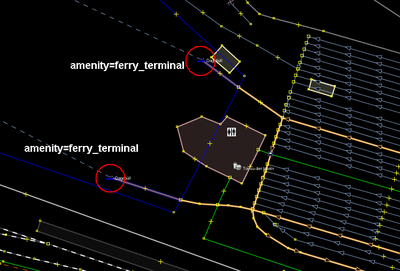
Example
| JOSM | Mapnik |
|---|---|

|
See also
- route=ferry - The route of a public ferry or water bus
- mooring=ferry
- Proposed_features/Seaway for a general port proposal
- Public transport - suggesting to deprecate this tag in favour of public_transport=platform + ferry=yes and public_transport=stop_position.

